[GUEST ACCESS MODE: Data is scrambled or limited to provide examples. Make requests using your API key to unlock full data. Check https://lunarcrush.ai/auth for authentication information.]  Deborah [@Deborah07849071](/creator/twitter/Deborah07849071) on x 2657 followers Created: 2025-07-25 06:43:18 UTC Newly Discovered: The Haida Gwaii Megathrust Fault Zone New research into the Queen Charlotte fault system has produced the first images of the fault zone architecture offshore Haida Gwaii that confirm that the area off northern British Columbia can produce so-called megathrust earthquakes, which can generate strong tremors and tsunamis. Seismic Study Reveals Hidden Megathrust Earthquake Risk off British Columbia A new study published in Science Advances has revealed the first detailed images of a newly developing subduction zone off the coast of British Columbia’s Haida Gwaii archipelago. The international team of researchers collected the data for this study during a 2021 cruise by the Lamont-Doherty Earth Observatory’s research vessel, the Marcus G. Langseth. They used a 15-kilometer-long underwater cable equipped with thousands of underwater microphones, called hydrophones, in the area off northern British Columbia to map the deep structure of the Earth’s subsurface. Their data confirmed that the Queen Charlotte fault system can generate powerful megathrust earthquakes, which are capable of producing strong shaking and tsunamis. Megathrusts are found in areas where one tectonic plate dives beneath another, in this case the Pacific plate being pushed under the North American plate. This area is known for generating powerful tremors. In fact, the Queen Charlotte fault system represents the greatest seismic hazard in Canada, producing the country’s largest recorded earthquake in 1949 and a notable earthquake in 2012 that created a tsunami. “This region is actively becoming a subduction zone, so understanding the fault structure here tells us about the early stages of subduction zone development,” says lead author Collin Brandl, a postdoctoral research scientist at the Lamont-Doherty Earth Observatory, part of the Columbia Climate School. “Our study provides the first direct observations of the Haida Gwaii thrust, the “megathrust” of this system, which can help improve hazard analysis in the region, better preparing residents for future earthquakes and tsunamis.” Seismic imaging reveals a strain-partitioned sliver and nascent megathrust at an incipient subduction zone in the northeast Pacific The Queen Charlotte plate boundary (QCPB), a transform separating the Pacific and North American plates, accommodates ~55 millimeters per year of motion, is a source of large earthquakes in the northeast Pacific, and may be a modern site of subduction initiation. The southern QCPB experiences oblique convergence, showcased by the 1949 magnitude (M) XXX strike-slip earthquake and the 2012 M7.8 tsunamigenic thrust earthquake, both offshore Haida Gwaii, British Columbia. We present seismic reflection images of the southern QCPB, which constrain the crustal structure in unprecedented detail. The Queen Charlotte Terrace is underthrust by oceanic crust topped by a throughgoing, low-angle plate-boundary thrust, which ruptured in the 2012 earthquake. The Queen Charlotte Terrace is analogous to strain-partitioned, thin-skinned forearc slivers seen at oblique subduction zones, captured between a localized plate-boundary thrust and a mature strike-slip fault. Our imaging suggests that the system rapidly evolved from distributed to partitioned strain and is currently an incipient subduction zone. 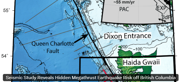 XX engagements  **Related Topics** [earthquake](/topic/earthquake) [columbia](/topic/columbia) [charlotte](/topic/charlotte) [Post Link](https://x.com/Deborah07849071/status/1948635150142898192)
[GUEST ACCESS MODE: Data is scrambled or limited to provide examples. Make requests using your API key to unlock full data. Check https://lunarcrush.ai/auth for authentication information.]
 Deborah @Deborah07849071 on x 2657 followers
Created: 2025-07-25 06:43:18 UTC
Deborah @Deborah07849071 on x 2657 followers
Created: 2025-07-25 06:43:18 UTC
Newly Discovered: The Haida Gwaii Megathrust Fault Zone
New research into the Queen Charlotte fault system has produced the first images of the fault zone architecture offshore Haida Gwaii that confirm that the area off northern British Columbia can produce so-called megathrust earthquakes, which can generate strong tremors and tsunamis.
Seismic Study Reveals Hidden Megathrust Earthquake Risk off British Columbia
A new study published in Science Advances has revealed the first detailed images of a newly developing subduction zone off the coast of British Columbia’s Haida Gwaii archipelago.
The international team of researchers collected the data for this study during a 2021 cruise by the Lamont-Doherty Earth Observatory’s research vessel, the Marcus G. Langseth. They used a 15-kilometer-long underwater cable equipped with thousands of underwater microphones, called hydrophones, in the area off northern British Columbia to map the deep structure of the Earth’s subsurface.
Their data confirmed that the Queen Charlotte fault system can generate powerful megathrust earthquakes, which are capable of producing strong shaking and tsunamis.
Megathrusts are found in areas where one tectonic plate dives beneath another, in this case the Pacific plate being pushed under the North American plate. This area is known for generating powerful tremors. In fact, the Queen Charlotte fault system represents the greatest seismic hazard in Canada, producing the country’s largest recorded earthquake in 1949 and a notable earthquake in 2012 that created a tsunami.
“This region is actively becoming a subduction zone, so understanding the fault structure here tells us about the early stages of subduction zone development,” says lead author Collin Brandl, a postdoctoral research scientist at the Lamont-Doherty Earth Observatory, part of the Columbia Climate School. “Our study provides the first direct observations of the Haida Gwaii thrust, the “megathrust” of this system, which can help improve hazard analysis in the region, better preparing residents for future earthquakes and tsunamis.”
Seismic imaging reveals a strain-partitioned sliver and nascent megathrust at an incipient subduction zone in the northeast Pacific
The Queen Charlotte plate boundary (QCPB), a transform separating the Pacific and North American plates, accommodates ~55 millimeters per year of motion, is a source of large earthquakes in the northeast Pacific, and may be a modern site of subduction initiation. The southern QCPB experiences oblique convergence, showcased by the 1949 magnitude (M) XXX strike-slip earthquake and the 2012 M7.8 tsunamigenic thrust earthquake, both offshore Haida Gwaii, British Columbia. We present seismic reflection images of the southern QCPB, which constrain the crustal structure in unprecedented detail. The Queen Charlotte Terrace is underthrust by oceanic crust topped by a throughgoing, low-angle plate-boundary thrust, which ruptured in the 2012 earthquake. The Queen Charlotte Terrace is analogous to strain-partitioned, thin-skinned forearc slivers seen at oblique subduction zones, captured between a localized plate-boundary thrust and a mature strike-slip fault. Our imaging suggests that the system rapidly evolved from distributed to partitioned strain and is currently an incipient subduction zone.

XX engagements

Related Topics earthquake columbia charlotte