[GUEST ACCESS MODE: Data is scrambled or limited to provide examples. Make requests using your API key to unlock full data. Check https://lunarcrush.ai/auth for authentication information.]  Deborah [@Deborah07849071](/creator/twitter/Deborah07849071) on x 2654 followers Created: 2025-07-24 22:43:57 UTC Massive 650-Foot Mega-Tsunami Sends Shockwaves Around the World – Satellite Footage Captures Unbelievable Destruction A colossal landslide in Greenland unleashed a mega-tsunami that sent seismic waves around the globe, shaking the Earth for days. In September 2023, a major geological event in Greenland’s Dickson Fjord caught the world’s attention. A landslide caused a massive tsunami that rippled through the Earth’s crust, sending seismic waves across the globe. The unusual phenomenon was so powerful that its effects were detected thousands of miles away, from Alaska to Australia. Scientists were left scrambling to understand the nature of these seismic pulses, which seemed far more persistent and slower than typical earthquake waves. The event has raised new concerns about the vulnerabilities of the Arctic, especially as climate change accelerates processes that lead to such disasters. A Tsunami Unlike Any Other On September 16, 2023, a staggering XX million cubic yards of rock and ice broke off from the cliffs of Greenland’s Dickson Fjord. The resulting mega-tsunami surged to a towering height of XXX feet (200 meters), enough to generate a shockwave that reverberated through the fjord and beyond. As the wave reached the headland, it bounced back in a phenomenon known as a seiche—a type of oscillating wave that caused the water to slosh back and forth. This unusual motion triggered more seismic activity, which continued for days after the initial impact. The immediate effects were felt at a research station on Ella Island, where equipment worth $XXXXXXX was damaged by the violent waters. What followed was far from typical, though. Instead of calming down, the waves created a prolonged rocking motion in the fjord that lasted far longer than expected, creating a distinct seismic signal that baffled scientists. The Mystery Behind the Seismic Waves What made this event truly unique, however, was the seismic signal it left behind. Unlike typical earthquake readings, which show sharp, jagged patterns, the seismic waves from the Greenland tsunami exhibited smooth, rhythmic peaks spaced XX seconds apart. These waves persisted for a full nine days—much longer than the brief tremors of a typical earthquake. It took more than XX researchers from various global institutions to crack the mystery. Alice Gabriel from UC San Diego’s Scripps Institution of Oceanography explained the challenge: “It was a big challenge to do an accurate computer simulation of such a long-lasting, sloshing tsunami.” Their efforts ultimately led them to conclude that the seismic signal was the result of standing waves in the fjord caused by the tsunami. Simulations indicated the waves reached about XX feet (9.14 m) in height, though there were still some discrepancies among the researchers about the exact measurements. Satellites Provide Critical Insights One of the major breakthroughs in understanding the event came from the use of advanced satellite technology. The Surface Water and Ocean Topography (SWOT) satellite, launched in December 2022, provided unprecedented high-resolution images of the fjord after the tsunami hit. Unlike traditional radar, which captures only narrow slices of data, SWOT can map a 30-mile-wide swath of ocean with incredible detail, offering a comprehensive view of the tsunami’s interaction with the fjord’s unique topography. This satellite technology was crucial in helping scientists monitor the disaster in ways that weren’t possible before. Thomas Monahan from Oxford University emphasized how next-generation Earth observation satellites like SWOT are transforming the way researchers understand these dynamic environments. The ability to see into such remote areas was key to monitoring the extreme forces at play in Greenland’s farthest corners. The Arctic’s Growing Risks While the tsunami itself was extraordinary, it also raises serious concerns about the changing Arctic. As global temperatures rise, glaciers and ice sheets are melting at unprecedented rates, destabilizing cliffs and slopes. This trend is making events like the Greenland landslide more likely. Kristian Svennevig from the Geological Survey of Denmark and Greenland noted that this event could be just the start of a troubling new pattern. Climate change is not a distant threat—it’s already reshaping the environment. The melting ice in Greenland is contributing to increased landslide frequency, which in turn heightens the risk of future tsunamis. As the Arctic becomes more accessible for research and tourism, it’s clear that authorities will need to develop more sophisticated monitoring and early-warning systems to track and respond to these rapidly evolving natural hazards. The full study was published in the journal Science and Nature Communications. June 2025 Observations of the seiche that shook the world On September 16th, 2023, an anomalous XXXXX mHz seismic signal was observed globally, persisting for X days. One month later an identical signal appeared, lasting for another week. Several studies have theorized that these signals were produced by seiches which formed after two landslide-generated mega-tsunamis in an East Greenland fjord. This theory is supported by seismic inversions, and analytical and numerical modeling, but no direct observations have been made. Here, we present primary observations of this phenomenon using data from the Surface Water Ocean Topography mission. By ruling out other oceanographic processes, we validate the seiche theory of previous authors and independently estimate its initial amplitude at XXX m using Bayesian machine learning and seismic data. This study demonstrates the value of satellite altimetry for studying fast oceanic processes and extreme events, while also highlighting the need for specialized methods to address the altimetric data’s limitations, namely temporal sparsity. These data and approaches will help in understanding future unseen extremes driven by climate change. 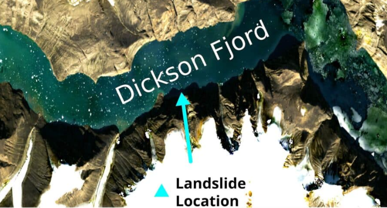 XX engagements  **Related Topics** [the worlds](/topic/the-worlds) [greenland](/topic/greenland) [Post Link](https://x.com/Deborah07849071/status/1948514517190934559)
[GUEST ACCESS MODE: Data is scrambled or limited to provide examples. Make requests using your API key to unlock full data. Check https://lunarcrush.ai/auth for authentication information.]
 Deborah @Deborah07849071 on x 2654 followers
Created: 2025-07-24 22:43:57 UTC
Deborah @Deborah07849071 on x 2654 followers
Created: 2025-07-24 22:43:57 UTC
Massive 650-Foot Mega-Tsunami Sends Shockwaves Around the World – Satellite Footage Captures Unbelievable Destruction
A colossal landslide in Greenland unleashed a mega-tsunami that sent seismic waves around the globe, shaking the Earth for days.
In September 2023, a major geological event in Greenland’s Dickson Fjord caught the world’s attention. A landslide caused a massive tsunami that rippled through the Earth’s crust, sending seismic waves across the globe. The unusual phenomenon was so powerful that its effects were detected thousands of miles away, from Alaska to Australia.
Scientists were left scrambling to understand the nature of these seismic pulses, which seemed far more persistent and slower than typical earthquake waves. The event has raised new concerns about the vulnerabilities of the Arctic, especially as climate change accelerates processes that lead to such disasters.
A Tsunami Unlike Any Other On September 16, 2023, a staggering XX million cubic yards of rock and ice broke off from the cliffs of Greenland’s Dickson Fjord. The resulting mega-tsunami surged to a towering height of XXX feet (200 meters), enough to generate a shockwave that reverberated through the fjord and beyond. As the wave reached the headland, it bounced back in a phenomenon known as a seiche—a type of oscillating wave that caused the water to slosh back and forth. This unusual motion triggered more seismic activity, which continued for days after the initial impact.
The immediate effects were felt at a research station on Ella Island, where equipment worth $XXXXXXX was damaged by the violent waters. What followed was far from typical, though. Instead of calming down, the waves created a prolonged rocking motion in the fjord that lasted far longer than expected, creating a distinct seismic signal that baffled scientists.
The Mystery Behind the Seismic Waves What made this event truly unique, however, was the seismic signal it left behind. Unlike typical earthquake readings, which show sharp, jagged patterns, the seismic waves from the Greenland tsunami exhibited smooth, rhythmic peaks spaced XX seconds apart. These waves persisted for a full nine days—much longer than the brief tremors of a typical earthquake. It took more than XX researchers from various global institutions to crack the mystery.
Alice Gabriel from UC San Diego’s Scripps Institution of Oceanography explained the challenge: “It was a big challenge to do an accurate computer simulation of such a long-lasting, sloshing tsunami.” Their efforts ultimately led them to conclude that the seismic signal was the result of standing waves in the fjord caused by the tsunami. Simulations indicated the waves reached about XX feet (9.14 m) in height, though there were still some discrepancies among the researchers about the exact measurements.
Satellites Provide Critical Insights One of the major breakthroughs in understanding the event came from the use of advanced satellite technology. The Surface Water and Ocean Topography (SWOT) satellite, launched in December 2022, provided unprecedented high-resolution images of the fjord after the tsunami hit. Unlike traditional radar, which captures only narrow slices of data, SWOT can map a 30-mile-wide swath of ocean with incredible detail, offering a comprehensive view of the tsunami’s interaction with the fjord’s unique topography.
This satellite technology was crucial in helping scientists monitor the disaster in ways that weren’t possible before. Thomas Monahan from Oxford University emphasized how next-generation Earth observation satellites like SWOT are transforming the way researchers understand these dynamic environments. The ability to see into such remote areas was key to monitoring the extreme forces at play in Greenland’s farthest corners.
The Arctic’s Growing Risks While the tsunami itself was extraordinary, it also raises serious concerns about the changing Arctic. As global temperatures rise, glaciers and ice sheets are melting at unprecedented rates, destabilizing cliffs and slopes. This trend is making events like the Greenland landslide more likely. Kristian Svennevig from the Geological Survey of Denmark and Greenland noted that this event could be just the start of a troubling new pattern.
Climate change is not a distant threat—it’s already reshaping the environment. The melting ice in Greenland is contributing to increased landslide frequency, which in turn heightens the risk of future tsunamis. As the Arctic becomes more accessible for research and tourism, it’s clear that authorities will need to develop more sophisticated monitoring and early-warning systems to track and respond to these rapidly evolving natural hazards.
The full study was published in the journal Science and Nature Communications.
June 2025 Observations of the seiche that shook the world On September 16th, 2023, an anomalous XXXXX mHz seismic signal was observed globally, persisting for X days. One month later an identical signal appeared, lasting for another week. Several studies have theorized that these signals were produced by seiches which formed after two landslide-generated mega-tsunamis in an East Greenland fjord. This theory is supported by seismic inversions, and analytical and numerical modeling, but no direct observations have been made. Here, we present primary observations of this phenomenon using data from the Surface Water Ocean Topography mission. By ruling out other oceanographic processes, we validate the seiche theory of previous authors and independently estimate its initial amplitude at XXX m using Bayesian machine learning and seismic data. This study demonstrates the value of satellite altimetry for studying fast oceanic processes and extreme events, while also highlighting the need for specialized methods to address the altimetric data’s limitations, namely temporal sparsity. These data and approaches will help in understanding future unseen extremes driven by climate change.

XX engagements

Related Topics the worlds greenland