[GUEST ACCESS MODE: Data is scrambled or limited to provide examples. Make requests using your API key to unlock full data. Check https://lunarcrush.ai/auth for authentication information.]  Deborah [@Deborah07849071](/creator/twitter/Deborah07849071) on x 2643 followers Created: 2025-07-24 03:04:53 UTC In the past XX hours, Oklahoma has had X quakes of magnitudes up to XXX. In the past X days, Oklahoma has had XX quakes of magnitudes up to 2.7: X quakes above magnitude X XX quakes below magnitude X that people normally don't feel. Latest today: Mag. XXX Earthquake X km ENE of Calumet, Oklahoma - XX minutes ago Strongest: Mag. XXX Earthquake Logan County, XX mi NE of Edmond, Oklahoma County, Oklahoma, United States - X days ago Past week: Mag. XXX on Saturday, Jul 19, 2025 – Logan County, XX mi NE of Edmond, Oklahoma County, Oklahoma, United States Past month: Mag. XXX on Wednesday, Jun 25, 2025 – XX mi NW of Ponca City, Kay County, Oklahoma, United States Past XX days: Mag. XXX on Wednesday, Jun 25, 2025 – XX mi NW of Ponca City, Kay County, Oklahoma, United States The New Madrid Seismic Zone When people think of earthquakes in the United States, they tend to think of the west coast. But earthquakes also happen in the eastern and central U.S. Until 2014, when the dramatic increase in earthquake rates gave Oklahoma the number one ranking in the conterminous U.S., the most seismically active area east of the Rocky Mountains was in the Mississippi Valley area known as the New Madrid seismic zone. Since 1974, seismometers, instruments that measure ground shaking, have recorded thousands of small to moderate earthquakes. The faults that produce earthquakes are not easy to see at the surface in the New Madrid region because they are eroded by river processes and deeply buried by river sediment. A map of earthquakes epicenters, however, reflects faulting at depth and shows that the earthquakes define several branches of the New Madrid seismic zone in northeastern Arkansas, southwestern Kentucky, southeastern Missouri, and northwestern Tennessee. Other relatively young faults, which are not necessarily associated with recent earthquakes, or the main seismicity trend in the New Madrid region, are shown in this map. It shows XX localities where geologists have found and published their findings on faults or evidence of large earthquakes (from sand blows; see image to the right). 1811-1812 Earthquakes In the winter of 1811 and 1812, the New Madrid seismic zone generated a sequence of earthquakes that lasted for several months and included three very large earthquakes estimated to be between magnitude X and X. The three largest 1811-1812 earthquakes destroyed several settlements along the Mississippi River, caused minor structural damage as far away as Cincinnati, Ohio, and St. Louis, Missouri, and were felt as far away as Hartford, Connecticut, Charleston, South Carolina, and New Orleans, Louisiana. In the New Madrid region, the earthquakes dramatically affected the landscape. They caused bank failures along the Mississippi River, landslides along Chickasaw Bluffs in Kentucky and Tennessee, and uplift and subsidence of large tracts of land in the Mississippi River floodplain. One such uplift related to faulting near New Madrid, Missouri, temporarily forced the Mississippi River to flow backwards. In addition, the earthquakes liquefied subsurface sediment over a large area and at great distances resulting in ground fissuring and violent venting of water and sediment. One account of this phenomena stated that the Pemiscot Bayou "blew up for a distance of nearly fifty miles." After the earthquake [of 1811-1812] moderated in violence, the country exhibited a melancholy aspect of chasms, of sand covering the earth, of trees thrown down, or lying at an angle of forty-five degrees, or split in the middle. The Little Prarie settlement was broken up. The Great Prarie settlement, one of the most flourishing before on the west bank of the Mississippi, was much diminished. New Madrid dwindled to insignificance and decay; the people trembling in their miserable hovels at the distant and melancholy rumbling of the approaching shocks. See also: Detailed Summary of the 1811-1812 New Madrid Earthquake Sequence 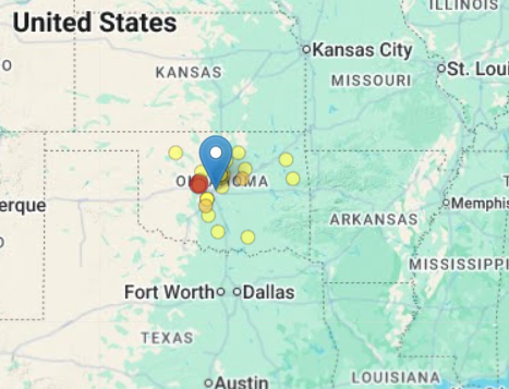 XX engagements  **Related Topics** [mi](/topic/mi) [earthquake](/topic/earthquake) [mag](/topic/mag) [Post Link](https://x.com/Deborah07849071/status/1948217798486008192)
[GUEST ACCESS MODE: Data is scrambled or limited to provide examples. Make requests using your API key to unlock full data. Check https://lunarcrush.ai/auth for authentication information.]
 Deborah @Deborah07849071 on x 2643 followers
Created: 2025-07-24 03:04:53 UTC
Deborah @Deborah07849071 on x 2643 followers
Created: 2025-07-24 03:04:53 UTC
In the past XX hours, Oklahoma has had X quakes of magnitudes up to XXX.
In the past X days, Oklahoma has had XX quakes of magnitudes up to 2.7:
X quakes above magnitude X XX quakes below magnitude X that people normally don't feel.
Latest today: Mag. XXX Earthquake X km ENE of Calumet, Oklahoma - XX minutes ago Strongest: Mag. XXX Earthquake Logan County, XX mi NE of Edmond, Oklahoma County, Oklahoma, United States - X days ago Past week: Mag. XXX on Saturday, Jul 19, 2025 – Logan County, XX mi NE of Edmond, Oklahoma County, Oklahoma, United States Past month: Mag. XXX on Wednesday, Jun 25, 2025 – XX mi NW of Ponca City, Kay County, Oklahoma, United States Past XX days: Mag. XXX on Wednesday, Jun 25, 2025 – XX mi NW of Ponca City, Kay County, Oklahoma, United States
The New Madrid Seismic Zone When people think of earthquakes in the United States, they tend to think of the west coast. But earthquakes also happen in the eastern and central U.S. Until 2014, when the dramatic increase in earthquake rates gave Oklahoma the number one ranking in the conterminous U.S., the most seismically active area east of the Rocky Mountains was in the Mississippi Valley area known as the New Madrid seismic zone. Since 1974, seismometers, instruments that measure ground shaking, have recorded thousands of small to moderate earthquakes. The faults that produce earthquakes are not easy to see at the surface in the New Madrid region because they are eroded by river processes and deeply buried by river sediment. A map of earthquakes epicenters, however, reflects faulting at depth and shows that the earthquakes define several branches of the New Madrid seismic zone in northeastern Arkansas, southwestern Kentucky, southeastern Missouri, and northwestern Tennessee. Other relatively young faults, which are not necessarily associated with recent earthquakes, or the main seismicity trend in the New Madrid region, are shown in this map. It shows XX localities where geologists have found and published their findings on faults or evidence of large earthquakes (from sand blows; see image to the right).
1811-1812 Earthquakes
In the winter of 1811 and 1812, the New Madrid seismic zone generated a sequence of earthquakes that lasted for several months and included three very large earthquakes estimated to be between magnitude X and X. The three largest 1811-1812 earthquakes destroyed several settlements along the Mississippi River, caused minor structural damage as far away as Cincinnati, Ohio, and St. Louis, Missouri, and were felt as far away as Hartford, Connecticut, Charleston, South Carolina, and New Orleans, Louisiana. In the New Madrid region, the earthquakes dramatically affected the landscape. They caused bank failures along the Mississippi River, landslides along Chickasaw Bluffs in Kentucky and Tennessee, and uplift and subsidence of large tracts of land in the Mississippi River floodplain. One such uplift related to faulting near New Madrid, Missouri, temporarily forced the Mississippi River to flow backwards. In addition, the earthquakes liquefied subsurface sediment over a large area and at great distances resulting in ground fissuring and violent venting of water and sediment. One account of this phenomena stated that the Pemiscot Bayou "blew up for a distance of nearly fifty miles."
After the earthquake [of 1811-1812] moderated in violence, the country exhibited a melancholy aspect of chasms, of sand covering the earth, of trees thrown down, or lying at an angle of forty-five degrees, or split in the middle. The Little Prarie settlement was broken up. The Great Prarie settlement, one of the most flourishing before on the west bank of the Mississippi, was much diminished. New Madrid dwindled to insignificance and decay; the people trembling in their miserable hovels at the distant and melancholy rumbling of the approaching shocks.
See also: Detailed Summary of the 1811-1812 New Madrid Earthquake Sequence

XX engagements

Related Topics mi earthquake mag