[GUEST ACCESS MODE: Data is scrambled or limited to provide examples. Make requests using your API key to unlock full data. Check https://lunarcrush.ai/auth for authentication information.]  Mario Nawfal [@MarioNawfal](/creator/twitter/MarioNawfal) on x 2.3M followers Created: 2025-07-15 22:30:00 UTC NASA’S LASER SATELLITE JUST STARTED MAPPING THE SEAFLOOR - FROM SPACE ICESat-2 was built to measure ice sheets. Instead, it’s accidentally become a bathymetry superstar. Turns out the satellite’s laser - designed to bounce off land - can also pierce crystal-clear coastal waters and reflect off the seafloor. Now with a new data product (ATL24), NASA and university researchers are using machine learning to map shallow ocean floors up to XXX feet deep - from orbit. Forget sonar ships. This is seafloor scanning via satellite. From the Bahamas to barrier reefs, what used to be “uncharted waters” just got a lot more mapped. Source: NASA, ICESat-2 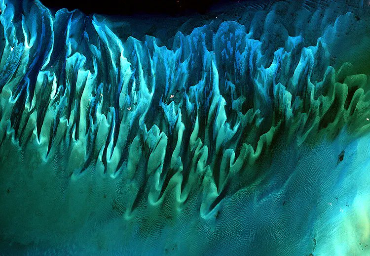 XXXXXX engagements  [Post Link](https://x.com/MarioNawfal/status/1945249518041042954)
[GUEST ACCESS MODE: Data is scrambled or limited to provide examples. Make requests using your API key to unlock full data. Check https://lunarcrush.ai/auth for authentication information.]
 Mario Nawfal @MarioNawfal on x 2.3M followers
Created: 2025-07-15 22:30:00 UTC
Mario Nawfal @MarioNawfal on x 2.3M followers
Created: 2025-07-15 22:30:00 UTC
NASA’S LASER SATELLITE JUST STARTED MAPPING THE SEAFLOOR - FROM SPACE
ICESat-2 was built to measure ice sheets. Instead, it’s accidentally become a bathymetry superstar.
Turns out the satellite’s laser - designed to bounce off land - can also pierce crystal-clear coastal waters and reflect off the seafloor.
Now with a new data product (ATL24), NASA and university researchers are using machine learning to map shallow ocean floors up to XXX feet deep - from orbit.
Forget sonar ships. This is seafloor scanning via satellite.
From the Bahamas to barrier reefs, what used to be “uncharted waters” just got a lot more mapped.
Source: NASA, ICESat-2

XXXXXX engagements
