[GUEST ACCESS MODE: Data is scrambled or limited to provide examples. Make requests using your API key to unlock full data. Check https://lunarcrush.ai/auth for authentication information.]  Not Op Cue [@NotOpCue](/creator/twitter/NotOpCue) on x 175.5K followers Created: 2024-04-25 08:06:13 UTC NASA Admits To Using Photoshop Images For Their Globe Earth Models 📸🌎🖥️🖱️ @NASA openly admits to using composite images numerous times on their own website. Which is just a fancy way of saying that they cut, paste and blend images of the flat Earth together using @Adobe @Photoshop editing every time they publish "new" images of the globe Earth model. Adobe Photoshop defines composite images as combining elements from multiple photographs into one image. On NASA's "Blue Marble" 2012 page they openly admit the globe model is a composite image composed of several swaths (broad photos): "A ‘Blue Marble’ image of the Earth taken from the VIIRS instrument aboard NASA’s most recently launched Earth-observing satellite – Suomi NPP. This composite image uses a number of swaths of the Earth’s surface taken on January 4, 2012." 🔗 On NASA's now deleted "VIIRS Eastern Hemisphere Image - Behind the Scenes" 2012 page they openly admit the globe model is a composite made using six separate orbits: "The new image is a composite of six separate orbits taken on Jan. 23, 2012 by the Suomi National Polar-orbiting Partnership satellite. Both of these new 'Blue Marble' images are images taken by a new instrument flying aboard Suomi NPP, the Visible Infrared Imaging Radiometer Suite (VIIRS)." 🔗 On NASA's "Blue Marble, Eastern Hemisphere" 2014 page they openly admit the globe model is a composite pieced together using eight orbits and ten imaging channels, then blended (a Photoshop feature): "The composite image of the eastern hemisphere was compiled from eight orbits of the satellite and ten imaging channels, then stitched together to blend the edges of each satellite pass." 🔗 ↙️↙️Read & Share The Full Article↘️↘️ 🔍"The Earth Is Flat & Stationary: Destroying The Freemasonic Luciferian Globalist "Globe" Lie" 💊 💊 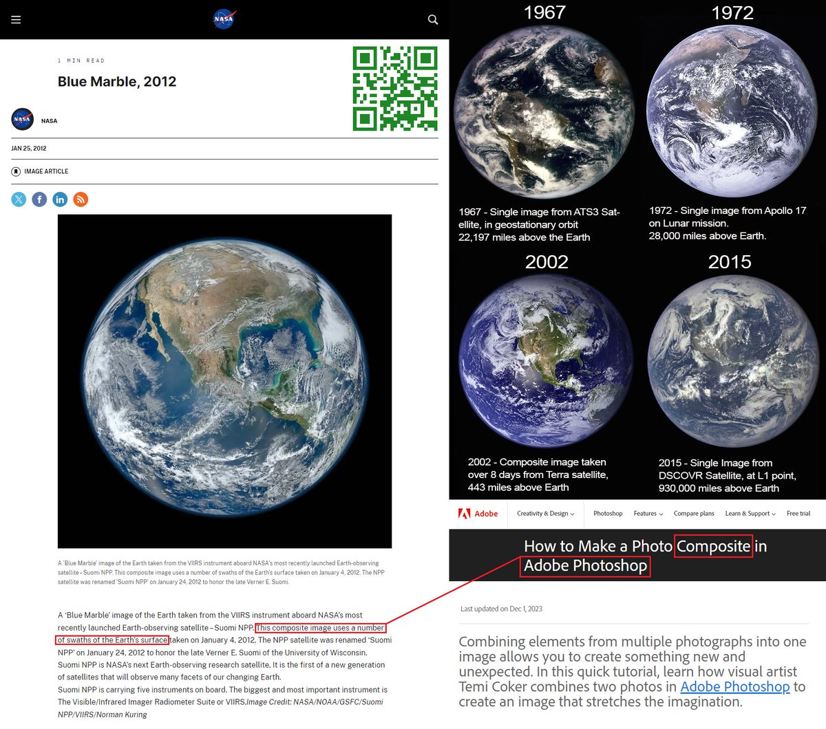 XXXXXXX engagements  **Related Topics** [adobe](/topic/adobe) [blend](/topic/blend) [photoshop](/topic/photoshop) [op](/topic/op) [Post Link](https://x.com/NotOpCue/status/1783407152675139786)
[GUEST ACCESS MODE: Data is scrambled or limited to provide examples. Make requests using your API key to unlock full data. Check https://lunarcrush.ai/auth for authentication information.]
 Not Op Cue @NotOpCue on x 175.5K followers
Created: 2024-04-25 08:06:13 UTC
Not Op Cue @NotOpCue on x 175.5K followers
Created: 2024-04-25 08:06:13 UTC
NASA Admits To Using Photoshop Images For Their Globe Earth Models 📸🌎🖥️🖱️
@NASA openly admits to using composite images numerous times on their own website. Which is just a fancy way of saying that they cut, paste and blend images of the flat Earth together using @Adobe @Photoshop editing every time they publish "new" images of the globe Earth model. Adobe Photoshop defines composite images as combining elements from multiple photographs into one image.
On NASA's "Blue Marble" 2012 page they openly admit the globe model is a composite image composed of several swaths (broad photos):
"A ‘Blue Marble’ image of the Earth taken from the VIIRS instrument aboard NASA’s most recently launched Earth-observing satellite – Suomi NPP. This composite image uses a number of swaths of the Earth’s surface taken on January 4, 2012." 🔗
On NASA's now deleted "VIIRS Eastern Hemisphere Image - Behind the Scenes" 2012 page they openly admit the globe model is a composite made using six separate orbits:
"The new image is a composite of six separate orbits taken on Jan. 23, 2012 by the Suomi National Polar-orbiting Partnership satellite. Both of these new 'Blue Marble' images are images taken by a new instrument flying aboard Suomi NPP, the Visible Infrared Imaging Radiometer Suite (VIIRS)." 🔗
On NASA's "Blue Marble, Eastern Hemisphere" 2014 page they openly admit the globe model is a composite pieced together using eight orbits and ten imaging channels, then blended (a Photoshop feature):
"The composite image of the eastern hemisphere was compiled from eight orbits of the satellite and ten imaging channels, then stitched together to blend the edges of each satellite pass." 🔗
↙️↙️Read & Share The Full Article↘️↘️
🔍"The Earth Is Flat & Stationary: Destroying The Freemasonic Luciferian Globalist "Globe" Lie" 💊 💊

XXXXXXX engagements
